You are here
Home ›Pays des trois rivières
Responsabilité du randonneur
|
The list of itineraries is a simple listing of trails open to horseback riders. It is necessary to check the usability of these trails with the organisation that manages them (Town or Departmental Council). Reminder: Riding can be dangerous on the trail. You should always be in control of your horse and adapt your behaviour and your gait to the environment. |
||
Didacticiel des cartes
Maps tutorialclick on icon (waypoint) The click on icon shows a popup that gives you details and information about different accommodations and equestrian centres.
Click on the departmental route
Click once on the departmental route to access to a button. Click on the button to view the page of the corresponding path.
|
||
Personnes concernées:
Meneurs
Distance:
23 kms
Duration:
1 jours
Percentage of paths:
60 %
Length of urban area:
0 kms
Car park address at starting point:
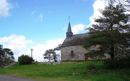
La chapelle des Lieux Saints
Other car parks:
parking de l'étang de la Roche
Description:
un itinéraire agréable dans un paysage vallonné.
auberge à l'étang de la Roche avec un paddock pouvant accueillir les chevaux.
Une crêperie
Remarkable sites:

La Chapelle des Lieux Saints
c'est là, qu'à une date très reculée, le IXème siècle disent les uns, XIème siècle disent les autres, que Sainte Anne aurait commencé à être honorée. Si l'on se reporte à l'historique du Château de Pontveix, on découvre qu'un seigneur du lieu, Maximilien de la Chénaie, aurait engagée Anne de Bretagne, en tournée de chasse dans les environs, à faire l'ascension de la Sainte Colline. http://www.mairie-guemene-penfao.fr/patrimoine.aspxhttp://www.mairie-guemene-penfao.fr/patrimoine.aspx
chateau de Juzet
Accommodations on the itinerary:
Url fiche touristique:
Downloads:
Printable map:


